|
Romancing the Road
by Bob Brooke
Today, many cars come
equipped with GPS. And if the car doesn’t have it, smartphones do.
As a result, a growing number of younger people cannot read road
maps. So when their car or phone’s GPS doesn’t work, they’re lost.
 But
maps don’t die. They’re as reliable as the information shown on
them. Ever since the invention of the automobile, road maps have
helped people reach their destinations—no voice required. But
maps don’t die. They’re as reliable as the information shown on
them. Ever since the invention of the automobile, road maps have
helped people reach their destinations—no voice required.
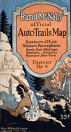
While state governments prepared topographical survey maps in the
19th century and many included some roads, the systematic mapping of
roads and the installation of route signs by them didn’t occur until
the auto arrived. Prior to the mid-1890s, bicyclists were the ones
who demanded road maps. But as the new century dawned, the number of
automobiles on the roads began to increase. The Chicago Times-Herald
printed the first automobile road map in the country for a race they
sponsored from Chicago to Waukegan.
 In
1918, Wisconsin’s state legislature initiated a numbered highway
system, which the federal government adopted in 1926. The new
highway system gave us the names for legendary roads like Route 66
or California’s scenic Highway 1. Rand McNally became the first
major publisher to adopt the system, which it also helped promote by
installing numbered signs along these national roadways. In
1918, Wisconsin’s state legislature initiated a numbered highway
system, which the federal government adopted in 1926. The new
highway system gave us the names for legendary roads like Route 66
or California’s scenic Highway 1. Rand McNally became the first
major publisher to adopt the system, which it also helped promote by
installing numbered signs along these national roadways.
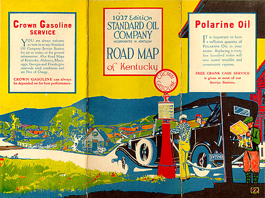
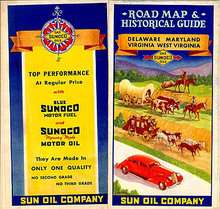
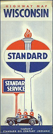 Before
the gas shortages of 1973, service stations gave out free road maps,
featuring elaborate artwork. Oil producers such as Esso, Chevron,
Shell, Gulf, Standard, Texaco, and Socony-Vacuum (later known as
Mobil) all distributed maps. Before
the gas shortages of 1973, service stations gave out free road maps,
featuring elaborate artwork. Oil producers such as Esso, Chevron,
Shell, Gulf, Standard, Texaco, and Socony-Vacuum (later known as
Mobil) all distributed maps.
Road maps belong to the growing category of collectibles called “petroliana,”
or anything to do with gas stations and the petroleum industry. For
the most part, they’re reasonably priced, and some estimate that
during their peak, service stations distributed over 8 billion. Oil
companies provided them as a service. They made them to be
disposable and easily marked up by the gas station attendant as he
gave directions and sent his customer on their way. But people often
saved maps as souvenirs of the trips they made.
As automobiles proliferated, the marking of routes changed. Before
numbered roads, stripes of paint on telephone poles, fence posts or
trees delineated the various routes. In 1925, states began numbering
their roads. At first it was an adventure to drive, but by the 1930s
it had turned into a method of tourism. Tourist cabins sprang up
along the way, as motorists made their way across country.
Historians consider this time the road map’s golden age.
 The
service station foreshadowed future marketing. It stands as one of
the first instances in which sellers of a commodity used names,
logos, graphics, color, architecture and other aspects of design to
create a branded variation on the standard item. The
service station foreshadowed future marketing. It stands as one of
the first instances in which sellers of a commodity used names,
logos, graphics, color, architecture and other aspects of design to
create a branded variation on the standard item.
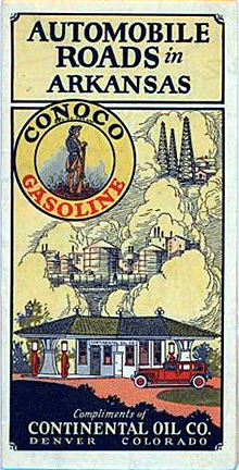
Hard as it is to imagine today, but shown in map illustrations,
service station chains competed on the cleanliness of their
restrooms and the helpfulness of their attendants, who not only
washed windshields and checked oil, but supposedly joked with
children and played with pets before handing the driver a free map
and sending the motorists on their happy way.
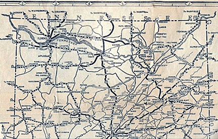
The evolution of the maps reflects changes in life on the road. The
early ones show the days before numbered roads. Routes were marked
like hiking trails in blazes — Strips of paint on telephone poles,
fence posts or trees, called blazes, delineated routes like the Red
Ball Route, the Kit Carson Trail, the Bee Line, and the Dixie
Highway.
 National standards for numbering roads arrived in 1925, and maps of
the 1920s and 1930s show adventure turning into tourism. Auto sales
rose and gas stations sprang up, with maps to hand out, their covers
showing beckoning horizons and gently rolling hills. National standards for numbering roads arrived in 1925, and maps of
the 1920s and 1930s show adventure turning into tourism. Auto sales
rose and gas stations sprang up, with maps to hand out, their covers
showing beckoning horizons and gently rolling hills.
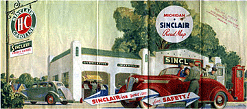
In the 1920s, maps often pictured airplanes, boats, and other
vehicles that used the fuel and oil produced by the company issuing
the map. By the 1930s, the golden era of the highway map, graphic
sophistication had increased.
The Sinclair Oil Company hired noted artists like Peter Helck, who
also produced advertising illustrations for car companies. Maps
featured images of a carefree and playful life on the road, with
service stations welcoming children and dogs, many of which were
Scottish terriers, like the ones popular in movies like “The Thin
Man.”
Maps produced during World War II reminded motorists to slow down to
save tires—the wartime speed limit was 35 miles an hour. After the
War, maps featured dynamic scenes, vibrant colors, and great
graphics.
By the baby booming 1950s, the images tended to show nuclear
families—a mom, dad, son and daughter, all enjoying life on the
road. During the 1960s, maps displayed the dotted lines of planned
Interstates and aerial views of highway cloverleafs.
 Three
companies—Rand McNally, H. M. Gousha, and General Drafting—produced
most of the service station maps. Bold travel images, in effect,
advertising for service stations surrounded the maps, themselves.
These became a vehicle through which oil companies could promote the
service at their stations, for it was service that differentiated
them. Three
companies—Rand McNally, H. M. Gousha, and General Drafting—produced
most of the service station maps. Bold travel images, in effect,
advertising for service stations surrounded the maps, themselves.
These became a vehicle through which oil companies could promote the
service at their stations, for it was service that differentiated
them.
This practice, known as “place product packaging,” stands as one of
the first instances in which sellers of a commodity used names,
logos, graphics, color, and architecture to create a branded
variation on the standard item. General Drafting produced maps for
Esso, whose
 attendants
handed out some 34.5 million maps in 1965. The 1960s maps showed the
dotted lines of planned Interstates and aerial views of highway
cloverleafs. After 1965, the quality of service station maps
declined until their virtual disappearance in the 1980s. attendants
handed out some 34.5 million maps in 1965. The 1960s maps showed the
dotted lines of planned Interstates and aerial views of highway
cloverleafs. After 1965, the quality of service station maps
declined until their virtual disappearance in the 1980s.
Today, of course, free maps are long gone. They faded away, along
with so many other aspects of the highway culture, with the 1973
energy crisis.
Road maps, especially the ones oil companies used to produce for
their service stations, are highly collectible. While older ones can
be worth higher amounts, depending on their condition, newer ones
aren’t as pricey. They’re also easy to store, so a collection won’t
take up a lot of room—always a good thing for those living in
apartments.
Early road maps from the first decade of the 1900s can be worth
$75-100 today in good condition. Those from the 1920s and 1930s
range in price from $20-40. Groups of maps from the 1950s sell for
$10-20.
<
Back to More Antique Spotlights
Next Article >
|